Newcastle City Council
Tree preservation zone
There is a problem
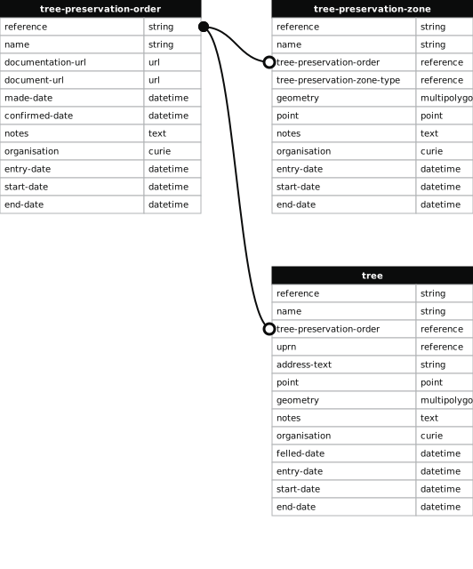
- 1000 entries with tree-preservation-order field must match the reference field in the tree preservation order dataset
High Gosforth Park
- reference
- 1995/017.A15
- name
- High Gosforth Park
- tree-preservation-order
- 1995/017
- tree-preservation-zone-type
- area
- geometry
- MULTIPOLYGON (((-1.618724 55.031934,-1.618760 55.031917,-1.618779 55.031894,-1.618808 55.031841,-1.618819 55.031767,-1.618824 55.031452,-1.618849 55.031351,-1.618877 55.031323,-1.618909 55.031297,-1.618906 55.031296,-1.618921 55.031286,-1.618908 55.031014,-1.618894 55.031005,-1.618859 55.030995,-1.618796 55.030981,-1.618680 55.030951,-1.618575 55.030912,-1.618586 55.029817,-1.618582 55.029805,-1.618572 55.029792,-1.618565 55.029786,-1.618550 55.029777,-1.618532 55.029770,-1.618516 55.029766,-1.618488 55.029763,-1.618465 55.029764,-1.618443 55.029768,-1.618427 55.029773,-1.618410 55.029781,-1.618401 55.029787,-1.618388 55.029801,-1.618383 55.029811,-1.618381 55.029820,-1.618383 55.029832,-1.618355 55.030942,-1.618320 55.030987,-1.618311 55.031819,-1.618346 55.031880,-1.618390 55.031920,-1.618448 55.031942,-1.618651 55.031942,-1.618690 55.031940,-1.618724 55.031934)))
- point
- POINT (-1.61855 55.031084)
- notes
- These data are update live via a feed to NCC's Tree Managament System, EzyTreev
- entry-date
- 2022-07-01
- start-date
- 1995-01-01
- end-date
How to fix this issue
Your data is missing a tree-preservation-order.
The tree preservation zone guidance explains how to fix the issue:
tree-preservation-order
The reference for the tree preservation order that covers this zone.
How to improve Newcastle City Council’s data
- Fix the errors indicated
- Use the check service to make sure the data meets the standard
- Publish the updated data on the endpoint URL